[update: added two panoramas]
Today started with a disappointment … After hauling ourselves to the airport to drop off our luggage so we could spend the day in Auckland free of them, we discovered that we could not take a bus to the nearby Otara Market as planned. The market only happens on Saturday mornings, but the bus from the airport to the Otara suburb … only runs Mon-Fri. Hmmph. Mmmmmkay, that just put us ahead of schedule on the rest of the day.
 Which basically consisted of taking a ferry from downtown Auckland to the island of Rangitoto in the bay. Rangitoto formed out of thin air (well, sea water) as a new undersea volcano erupted about 600 years ago and thrust this new island up out of the water. It’s a couple miles around and has the familiar cone at the center, albeit a small one.
  What’s really amazing about this island is that the lava hasn’t broken down into soil yet, so most of the island is covered in this surreal deep-black fluffy-looking stuff that is actually volcanic rock. In some places a couple inches of soil has formed (starting with lichen on the rocks) and so you do have some plant life. But mostly it’s either bare black fluffy rock moonscape (despite 600 years of weathering) or overgrown with low plants that can eke out a life on the meager soil so far.
 So in contrast to our self-guided travels for this entire trip, today we paid for the ferry ride out and went on a guided tour of the island. We piled into this tractor-trailer rig (with mostly retirees and toddlers) and went on a slow and impossibly bumpy ride around the island, with commentary by the tractor driver up front.
We had killer views of Auckland from the top of the volcano, of course. This first one shows the city of Auckland in the distance (not that far actually) in the center of the image, with the bays stretching from horizon to horizon littered with weekend sailboats. City of Sails indeed.

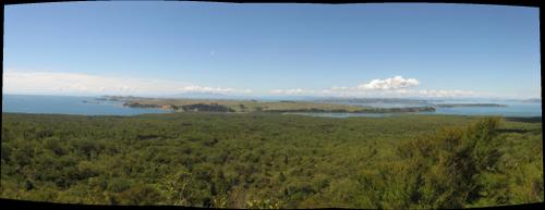
This last panorama shows the view from Rangitoto to the east. The newer volcanic island (600 years old) is right next to an older island (millions of years) that is basically farmland. In the far distance are the barrier islands and the Coromandel peninsula, or so we were told:

The ferry brought us back to the downtown wharf at around 4:15 pm, leaving us time to goof around downtown a little bit more and then take the airport shuttle back to the airport with time there to eat and relax a bit. However, that actually turned into something of a debacle, but that’s for part 2 of our marathon Saturday …